Operation Fleet Finder: Identifying a Carrier Nobody Can See
Bellingcat Maritime Mysteries. Grey carriers at a pier, no EXIF, and no hull number on the ship in question. A pier sign, the camera position and the 2024 fleet movements narrow it to one carrier: USS George H.W. Bush.
Title: Operation Fleet Finder (Bellingcat Challenge, Maritime Mysteries series)
Description: From grey sky to grey ships. Here are a handful of naval ships moored together, but grey is the only colour in sight. They all look the same! Can you help identify them?
Question: What is the MMSI number for the left-most ship?
The left-most ship is USS George H.W. Bush (CVN-77), and the hull number that would prove it is not in the photo. The challenge site accepted the answer.
369970663Public writeups of this challenge already exist (eDiscovery Channel, 16 December 2024, gudini1, 20 December 2024). Both match the island against reference photos of the Norfolk carriers. This writeup adds the location and the calendar, so the answer holds even without a reference photo.
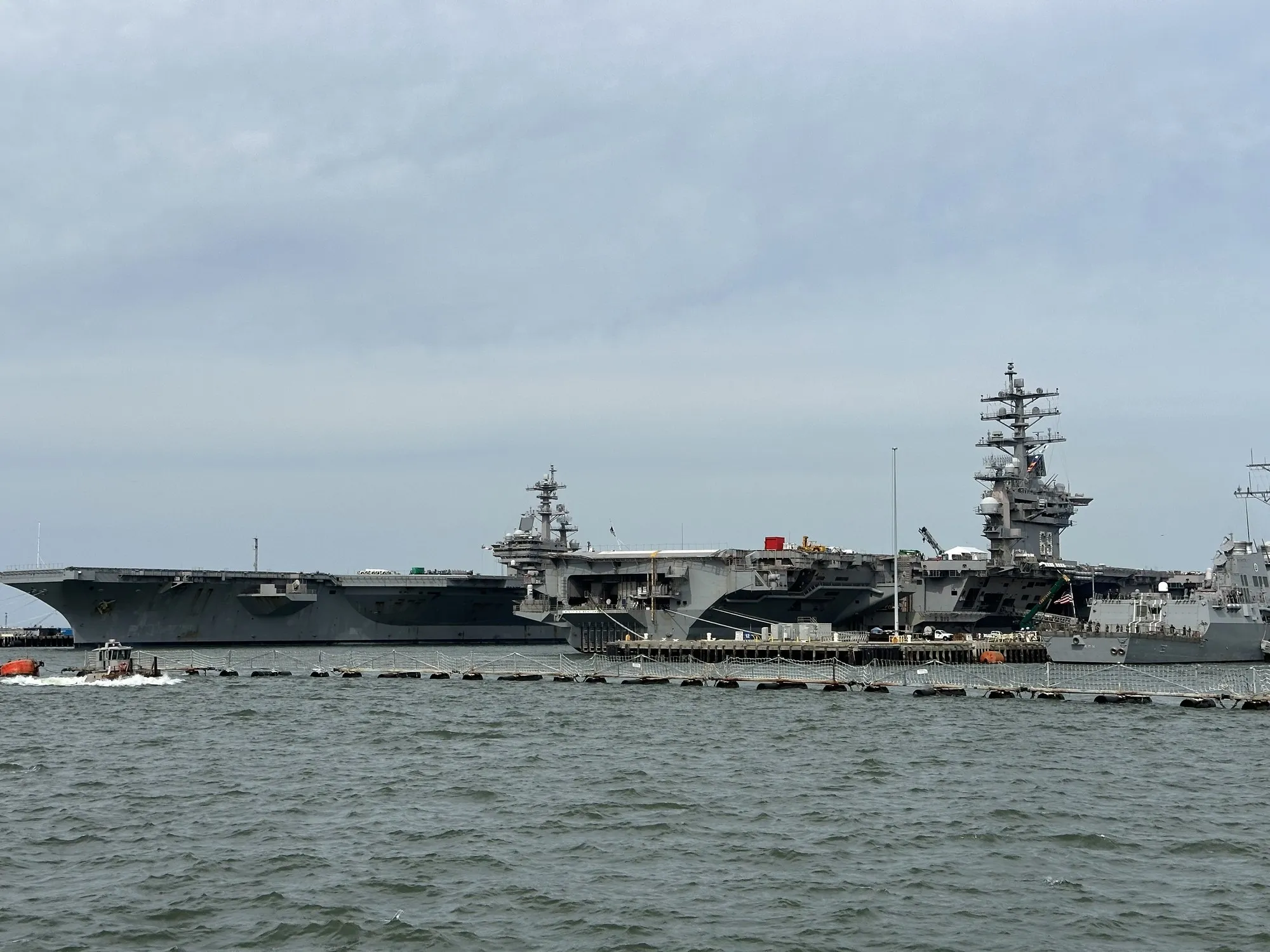
The whole brief. The original file (4032 × 3024, hosted by Bellingcat) has no EXIF: no camera, no date, no GPS. Everything has to come from the pixels.
What the photo does not give you: a hull number, a name or a flight-deck number on the ship in question. The left carrier can’t be read off the image. It has to be narrowed down.
Reading the image
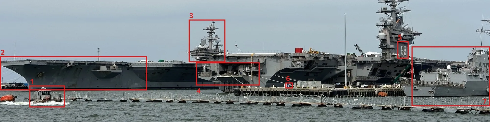
The seven things the solve rests on. 1 is underway, 2 and 3 are the ship in question, 4 and 5 are Ike, 6 is the pier, 7 is a destroyer.
Which ship is “left-most”? A small tug (1) runs through the left edge of the frame with a bow wave. It is underway, not moored, so it is out. The left-most moored ship is the carrier whose bow fills the left third of the image (2).
The right carrier. Its island carries a large white hull number (5). At full resolution it reads 69, which makes it USS Dwight D. Eisenhower (CVN-69). Aggressive upscaling made the second digit look like an 8 for a moment. A clean crop settles it as a 9.
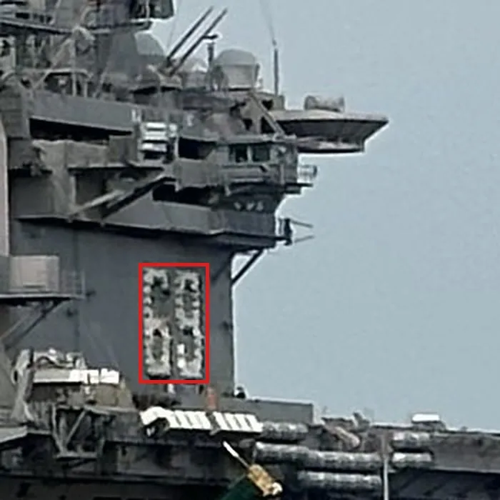
Native resolution, 2× enlarged without sharpening: the hull number on Ike’s island.
Ike’s stern. The middle of the image is not a third ship. It is Ike’s fantail (4), with hangar opening, elevators and the nameplate DWIGHT D. EISENHOWER. Ike lies bow-right.
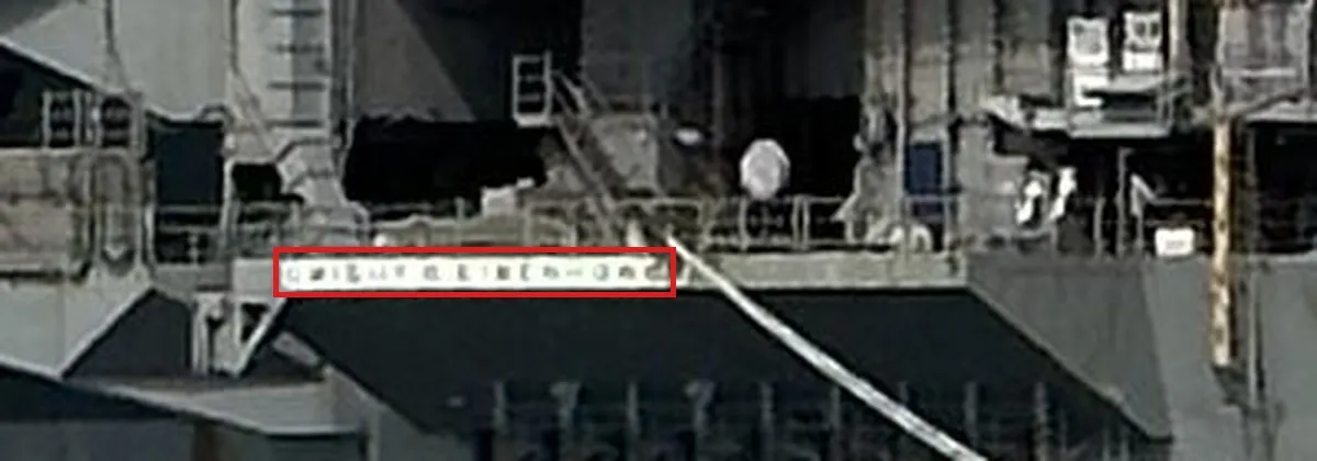
The nameplate on the stern. Too small to read letter by letter, but too long for any other name in the class, and it sits on the same ship as the 69.
The left carrier. Its bow points left. No hull number is visible on the bow, which is normal, since Nimitz-class carriers carry their numbers on the island and flight deck, not the hull side. Its island (3) is the one rising behind Ike’s stern: further away from the camera, seen from the port quarter. It is a Nimitz-type island with a central lattice mast and rotating radars. That alone rules out USS Gerald R. Ford, whose island sits about 140 feet further aft with flat-panel radars (Gerald R. Ford class).
Right edge. An Arleigh Burke-class destroyer (7), closest to the camera.
How sure? Ike is solid: hull number and nameplate are two features on one ship. “Nimitz-type, not Ford” is solid too, the island position alone settles it. Which Nimitz carrier is still completely open.
Pier geometry
The photo was taken from the water southwest of Pier 12, Naval Station Norfolk, looking northeast. Ike sits on the north side of Pier 12, the left carrier on the south side of Pier 14.
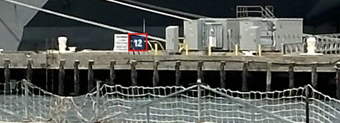
The pier sign in front of Ike reads 12.
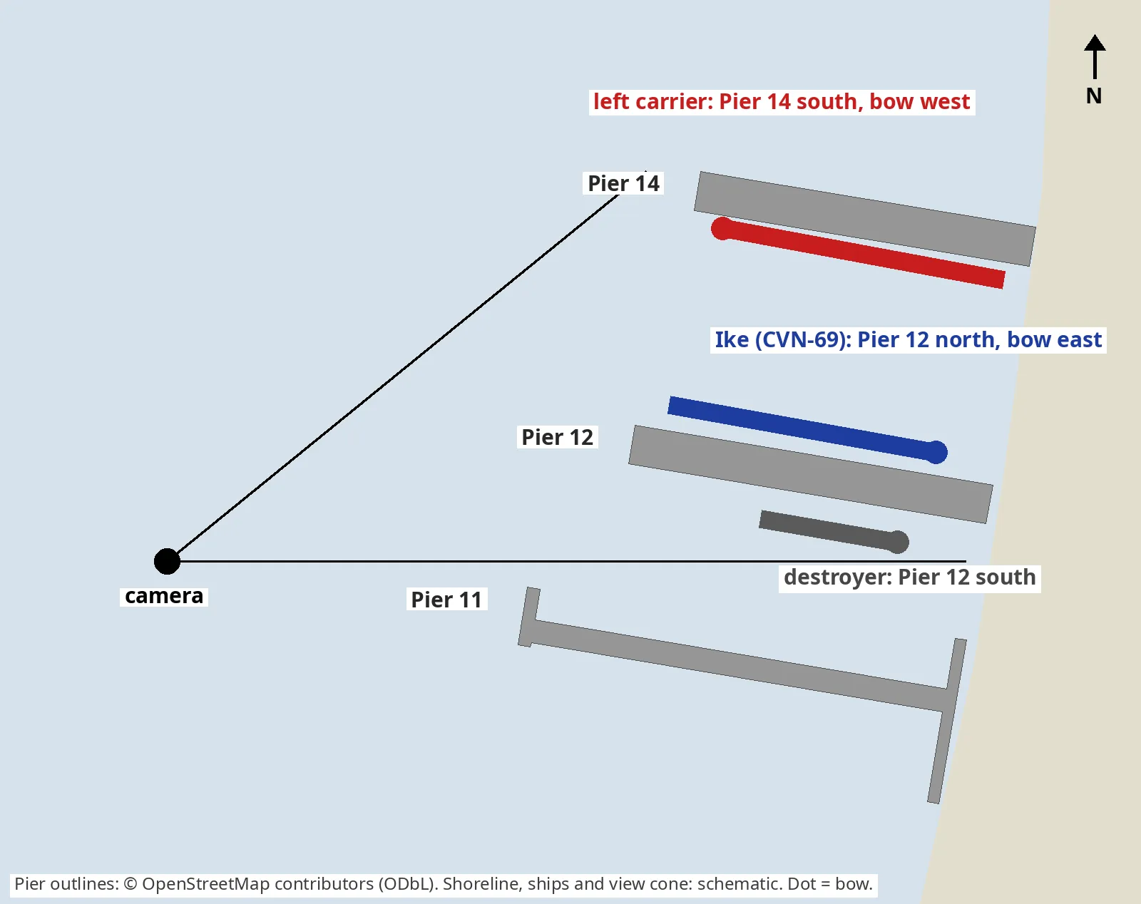
Pier outlines from OpenStreetMap, ships and view cone schematic. From the water west of the pier heads, Pier 12 and its destroyer are in front, Ike is behind the pier, and the only berth behind Ike’s stern is Pier 14 south.
- The pier sign. A small sign on the pier in front of Ike reads 12. Naval Station Norfolk’s carrier piers are 11, 12 and 14, in a row along Sewells Point.
- Pier in front, ship behind. Pier 12 runs between the camera and Ike, so Ike is on the far side, the north side. The destroyer on the right sits on the near (south) side of the same pier.
- Camera position. That puts the photographer southwest of the pier heads, on the water behind the security barrier. Harbour tour boats run exactly this route.
- The left carrier. It lies behind Ike’s stern, so it is further north. The next berth north of Pier 12 is the south side of Pier 14. Pier 11 is south of 12 and would sit in front of Ike, not behind it.
- Headings. Ike’s stern points west to the pier head (bow inland). The left carrier’s bow points west (bow out). They face opposite ways across the slip between Piers 12 and 14.
Google Earth imagery of the base shows exactly this constellation: a carrier on Pier 12 north, island on its south side (bow east); a carrier on Pier 14 south, island on its north side (bow west); a destroyer on Pier 12 south.
To check it yourself: Google Earth Pro, View → Historical Imagery, at
36.9580, -76.3300The pier outlines and numbers are also in OpenStreetMap (Pier 12, way 623235098).
How sure? The berth is solid: the sign, the order of the piers and the headings all agree. But a berth says nothing about which carrier is in it. That needs a date.
Building a time window
With no EXIF, the date comes from ship movements: Ike and Bush were only both at Naval Station Norfolk from 16 November 2024 onward, and the challenge was public by 16 December 2024.
- Upper bound. The earliest public writeup of the series is dated 16 December 2024, so the photo is older than that.
- Ike. Returned to Naval Station Norfolk in July 2024 after a nine-month Red Sea deployment, and left for Norfolk Naval Shipyard on 8 January 2025. Before that, as much work as possible was done pierside, which matches the crane, tents and containers on Ike’s deck in the photo.
- Bush. In the shipyard from January 2024, back at Naval Station Norfolk on 16 November 2024.
To reproduce these dates, search the USNI News fleet tracker and the Navy’s own press channels:
site:news.usni.org "Fleet and Marine Tracker" December 2024
site:dvidshub.net "George H.W. Bush" Norfolk Naval Shipyard 2024
site:dvidshub.net "Dwight D. Eisenhower" Norfolk Naval Shipyard
Then every other carrier that could plausibly sit at Pier 14 in late 2024:
| Carrier | Where, late Nov – mid Dec 2024 | Verdict |
|---|---|---|
| Harry S. Truman (CVN-75) | Deployed: passed Gibraltar 25 Nov, Mediterranean / Red Sea (USNI, 2 Dec) | Out |
| Gerald R. Ford (CVN-78) | Back in Norfolk 15 Dec (USNI, 16 Dec) | Out: island far aft, wrong shape |
| George Washington (CVN-73) | Left Norfolk for Japan on 25 April 2024 | Out |
| George H.W. Bush (CVN-77) | Naval Station Norfolk from 16 Nov | In |
The remaining Nimitz carriers were on the West Coast, in Japan, or in overhaul at Newport News, not at a Naval Station Norfolk pier.
How sure? As sure as the window. If the photo were older than Bush’s return, other carriers come back into play (see the June 2023 trail below). The window is what makes it a list of one.
The moment it’s settled: the table. With Ike’s dates and the writeup date as bounds, Bush is the only Nimitz carrier that was at a Naval Station Norfolk pier at the same time as Ike.
Cross-check: the island
The calendar leaves one candidate, so the photo should match it. Against a US Navy photo of Bush:
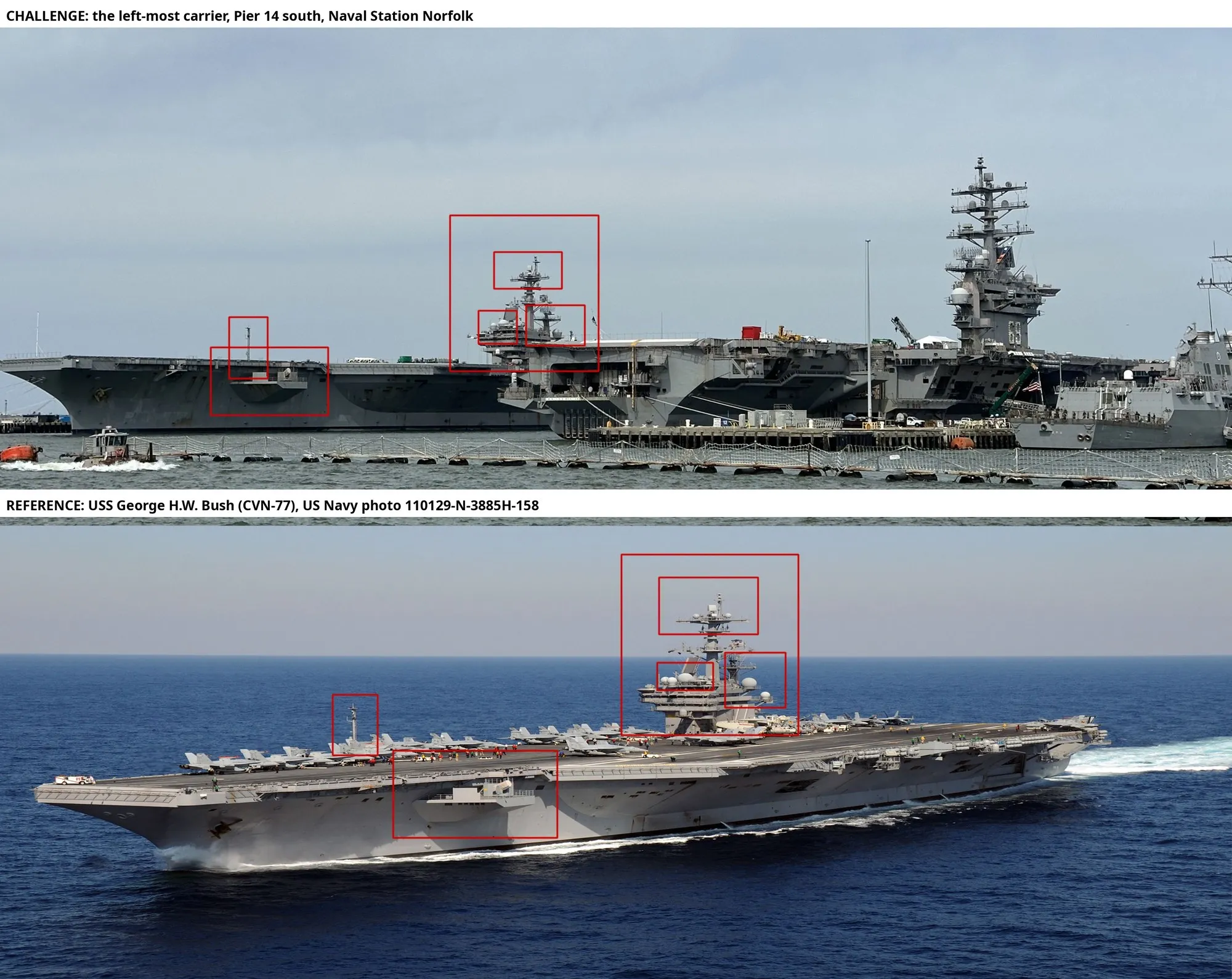
Top: the left carrier, seen past Ike’s stern. Bottom: USS George H.W. Bush, US Navy photo 110129-N-3885H-158. Island mast, radar platforms, aft pole mast and hull sponson sit in the same places.
This is a consistency check, not the identification. Late Nimitz carriers share most of these features, which is why the calendar has to do the work.
Dead ends and false trails
Four leads looked useful and weren’t, each for a reason worth knowing.
- 68 or 69. An upscaled crop of Ike’s island made the hull number read as 68, USS Nimitz, which only moved to Norfolk in July 2026. Upscaling invents edges. A clean crop at native resolution reads 69.
- The 2012 Reddit photo. Searching “Eisenhower and Bush moored together” leads to a 2012 aerial of Ike arriving at Norfolk with Bush at the piers. Proof that both use these piers, nothing more. Berths change constantly, and the layout in that photo is mirrored relative to the challenge image.
- Sentinel-2. Free and global, but 10 m per pixel: a carrier is a 33 × 8 pixel smudge. Enough to count carriers at a pier on a given day, never enough to identify one. The Esri Sentinel-2 Explorer is noticeably faster than the Copernicus Browser for scrubbing dates.
- Google Earth, 14 June 2023. Sharp Airbus imagery shows the exact constellation: Ike on Pier 12 north, a carrier on Pier 14 south, bow west. Ike’s deck reads 69; the other deck shows no number. Bush does carry “77” on its bow in other imagery, so the unnumbered ship was probably George Washington, fresh out of a six-year overhaul in May 2023. In June 2023, Truman was in the shipyard and Ford deployed, so GW and Bush were both candidates then. The lesson: the same berth and heading tell you nothing about which carrier. Only the date does.
Solution
369970663USS George H.W. Bush (CVN-77), MMSI 369970663, south side of Pier 14, Naval Station Norfolk.
The chain, in order:
- The right carrier is Ike (69 on the island, nameplate on the stern).
- The pier is Pier 12, Naval Station Norfolk; the left carrier lies on Pier 14 south.
- The left carrier has a Nimitz-type island, so it is not Ford.
- Ike was at the Naval Station from July 2024 to 8 January 2025; the challenge was public by 16 December 2024.
- In that window, Truman was deployed and George Washington was in the Pacific. Bush was back from 16 November.
- The only Nimitz carrier besides Ike at the piers: Bush.
The accepted answer also dates the photo: almost certainly between 16 November and mid-December 2024. The MMSI is listed in Bush’s ship data.
Takeaways
- When the object can’t identify itself, the calendar can. Movement data from fleet trackers and Navy press releases turned an unreadable carrier into a list of one.
- Work out where the camera stood. A single pier sign plus “pier in front, ship behind” fixed both berths and headings.
- Same berth is not same ship. A perfect constellation match from another date is evidence of how the base is used, not of who was there.
- Don’t upscale numbers. Read digits at native resolution.
- The right answer is the start, not the writeup. The answer was “Bush” all along. The work was proving it.
Sources
- Bellingcat Challenge 7: Operation Fleet Finder
- eDiscovery Channel: Bellingcat Challenge week 2 writeup, 16 December 2024
- gudini1: Bellingcat Challenge Writeup, Maritime Mysteries, 20 December 2024
- Stars and Stripes, 14 January 2025: USS Eisenhower arrives in Norfolk for maintenance period
- DVIDS: USS Dwight D. Eisenhower transits to Norfolk Naval Shipyard
- USNI News, 18 November 2024: Carrier USS George H.W. Bush wraps up maintenance period, sea trials
- USNI News, 25 November 2024: Carrier USS Harry S. Truman now in the Mediterranean
- USNI News Fleet and Marine Tracker, 2 December 2024
- USNI News Fleet and Marine Tracker, 16 December 2024
- USNI News, 9 July 2026: USS Nimitz arrives in Norfolk for homeport shift
- Wikipedia: USS George Washington (CVN-73)
- Wikipedia: USS George H. W. Bush, MMSI 369970663
- Wikipedia: Gerald R. Ford-class aircraft carrier
- Wikimedia Commons: US Navy 110129-N-3885H-158, USS George H.W. Bush underway in the Atlantic
- Esri Sentinel-2 Explorer · Copernicus Browser