Corrupted — Finding a Town Behind Black Squares
A GEOINT writeup: geolocating a censored Street View panorama in the Italian Alps using nothing but a poem's four constraints. Why the four black squares point at the poem, not at the picture.
The Challenge
The setup: a “found backpack” with an SD card containing two files. A .png — a Street View panorama with several black squares slapped over it, “corrupted” — and a .txt with a short poem:
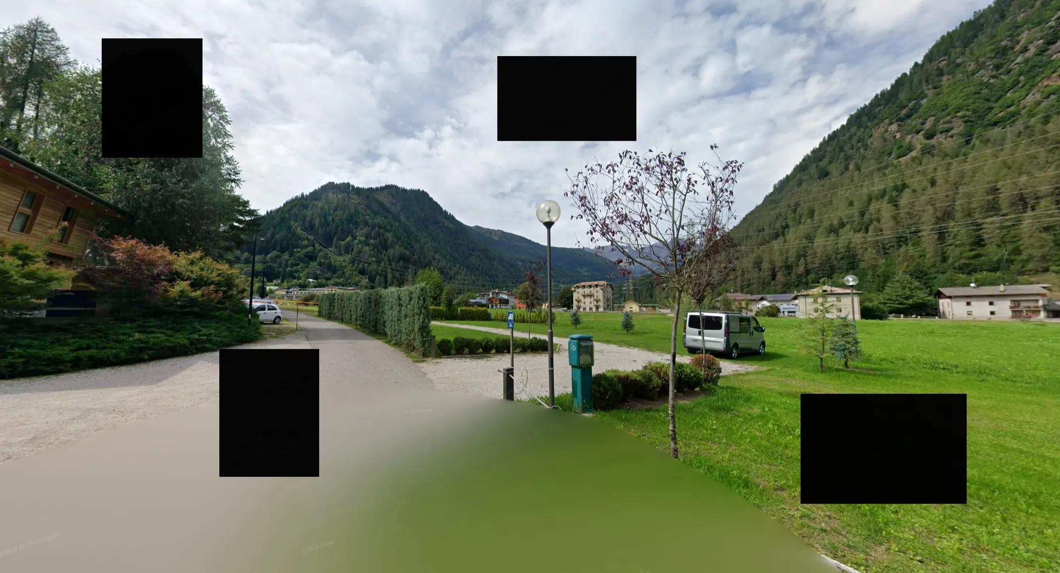
Four squares, one per landmark in the poem. They sit in the sky and the foreground and cover nothing in the picture: they are a count, not a redaction.
A valley framed in stone and shade,
Where four distinct clues are displayed:
A green grass soccer field below,
Two church towers standing in a row.
A castle perched upon its rock,
A nearby creek that winds and talks.
Cross the stream and match the view
Which town is calling you?
Flag format: hacktoria{lat,long} or a Google Maps URL.
The town: Ossana, Val di Sole, Trentino — camera at 46.3110, 10.7367, on the cycle path across the Torrente Vermigliana. If you just want the answer, that’s it. The interesting part is that the “corruption” sends you to the poem.
First Instinct (and Why It Was Wrong)
My honest first reaction to the image: is this England? Globe streetlamps, green fields, grey sky — it had that vibe for a second.
It wasn’t. And the terrain kills that theory on its own: the slopes in frame are continuous forested flanks rising into rocky summits. That’s 2000m+ alpine relief. England doesn’t have that; even the Lake District is rolling hills by comparison. Bavaria was the better counter-argument — the German Alps can absolutely look like this — but a single frame was never going to settle it. The poem was.
Lesson one: don’t geolocate vibes from a single frame when the challenge hands you hard constraints for free.
What the Image Actually Gives You
Ignoring the black squares, the uncensored parts still carry signal:
- Alpine valley, steep forested slopes on both sides, high-voltage lines strung across the valley floor — classic alpine valley infrastructure
- A paved cycle path with a trimmed hedge, gravel parking, a camper van — this smells like a campground or rest area on a valley bike route
- A teal service/SOS column of the type found along Italian cycle routes
- Wooden chalet on the left with a flat-pitched roof and balconies — Trentino-style construction, not remotely British
© 2026 Googlewatermark — so this is a plain Street View screenshot, meaning the exact camera position exists and is findable
Region hypothesis after the visual pass: Trentino, Northern Italy — Val di Sole or Val Rendena territory.
How Do You Even Tell Italy From Bavaria?
Fair question, because the German Alps can look nearly identical at first glance. The strongest discriminator isn’t the mountains — it’s the residential buildings in the background, not the chalet up front. Look at the large yellowish multi-storey house mid-right and the houses along the valley edge: plastered facades, symmetric window rows, shallow-pitched gable roofs, external balconies running the full width of the facade. That’s Italian alpine construction (Trentino / South Tyrol / Lombardy). Bavarian and Austrian villages read differently — deeper roof overhangs, Lüftlmalerei facade painting, more visible timber on residential buildings, different proportions.
Weaker but consistent signals stack on top: the teal column is the type of cycle-route service point found along Italian valley bike paths, the trimmed cypress-style hedge is unusual as bike-path greenery in Germany, and the vegetation mix on the slopes fits the southern side of the Alps.
Important caveat: this made Trentino a ranked hypothesis, not a certainty. Bavaria couldn’t be fully excluded from the frame alone — and it didn’t need to be. A hypothesis costs one search query to test. If Trentino had come up empty against the poem’s constraints, Bavaria was next in line. Rank your hypotheses, test the cheapest one first, and don’t fall in love with any of them.
The Poem Is the Actual Challenge
Here’s the trick of this challenge: the black squares aren’t corruption, and they aren’t redactions either. Two sit in the sky, two in the foreground; nothing is under them. There are four because the poem names four landmarks, and the poem is where the information is:
- A soccer field
- Two church towers in a line
- A castle on a rock
- A creek
- The camera is across the stream from the town
Individually, each clue is weak. Together, they’re a database query. “Castle perched on a rock in the valley floor” is the rarest of the four — that alone filters out almost every alpine village. Add “creek directly below” and “soccer field within sight” and you’re down to a handful of candidates in the entire Alps.
Running the Query
One thing that does not work: searching the constraint globally. Try castle on a rocky outcrop above a creek and Google hands you Eltz Castle, Cilgerran in Wales, and a pile of Rhine fortresses — pure noise. The rarest constraint is only useful after the image analysis has pinned the region. Order of operations matters:
- Image → region. Terrain, architecture and infrastructure said Trentino (see above). That’s the filter.
- Region + rarest constraint → candidates. Now the query becomes something like
castello roccia torrente Val di Soleorcastle rock Trentino valley— or, alternatively, skim Wikipedia’s list of castles in Trentino and keep only the ones sitting on valley-floor rock outcrops next to a stream. Either way you land on a handful of candidates, and one dominates: Castello di San Michele in Ossana, Val di Sole, on a rock spur directly above the Torrente Vermigliana. - Candidate → cross-check the remaining constraints.
Checking the rest of the constraints around Ossana:
- Creek — Torrente Vermigliana runs right past the village and the local campground
- Soccer field — Campo sportivo on Via di Sotto Pila, in the valley floor
- Two church towers in a row — the bell tower of San Vigilio in Ossana plus the tower of neighbouring Fucine; from across the valley they line up visually
- “Cross the stream and match the view” — the north side of the Vermigliana has a cycle path and camper area at Camping Cevedale, matching the parking lot, hedge and service column in the image
Everything sits inside a ~400m radius. That’s not a coincidence, that’s the answer.
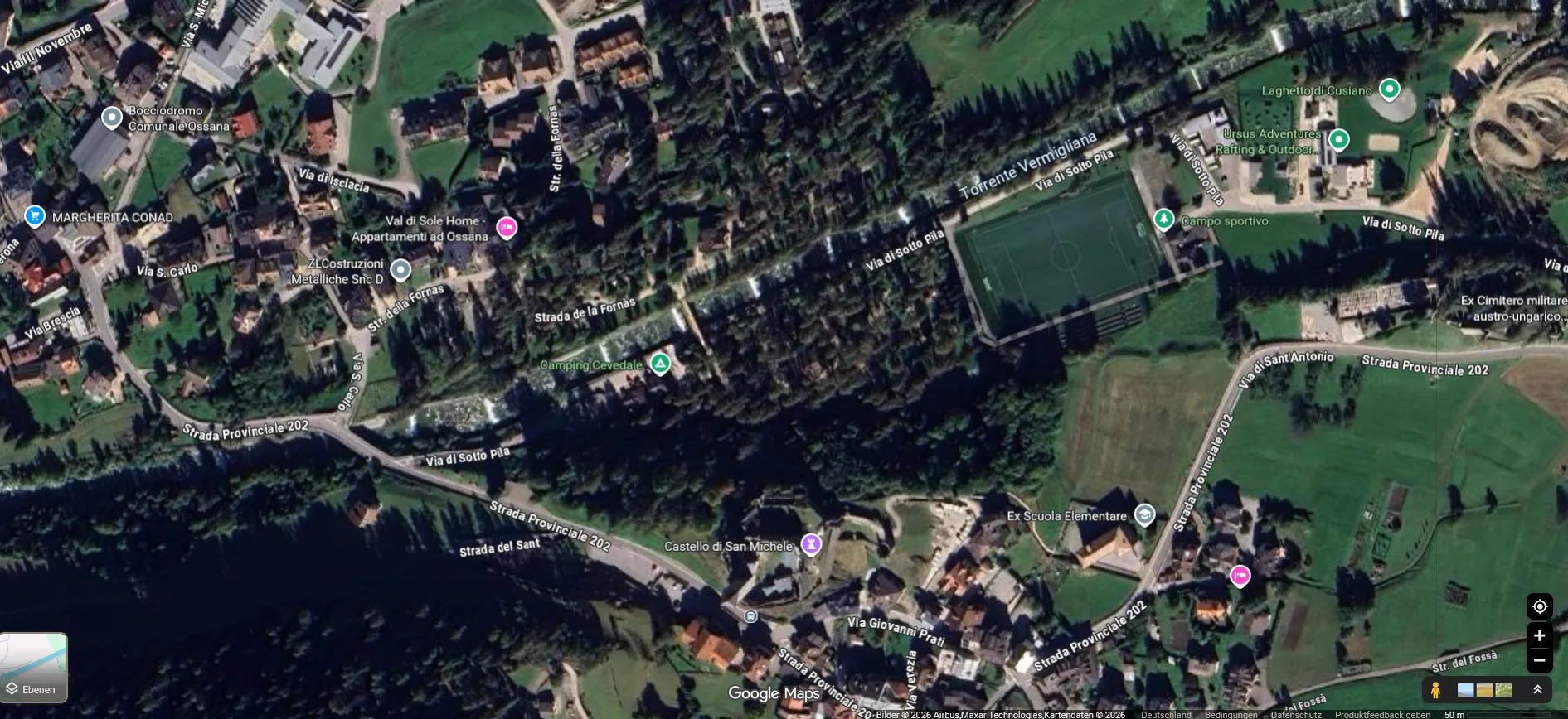
All four poem constraints inside a ~400 m radius — castle on its rock, soccer field, both towers, the creek, and the camera across the stream.
Verification
Dropped into Street View near Camping Cevedale and walked the cycle path — Str. della Fornas, Ossana (imagery from Sept. 2025) matches the challenge image: same globe lamp, same hedge along the path, same gravel lot, same teal column, and an identical mountain profile down the valley. Confirmed.
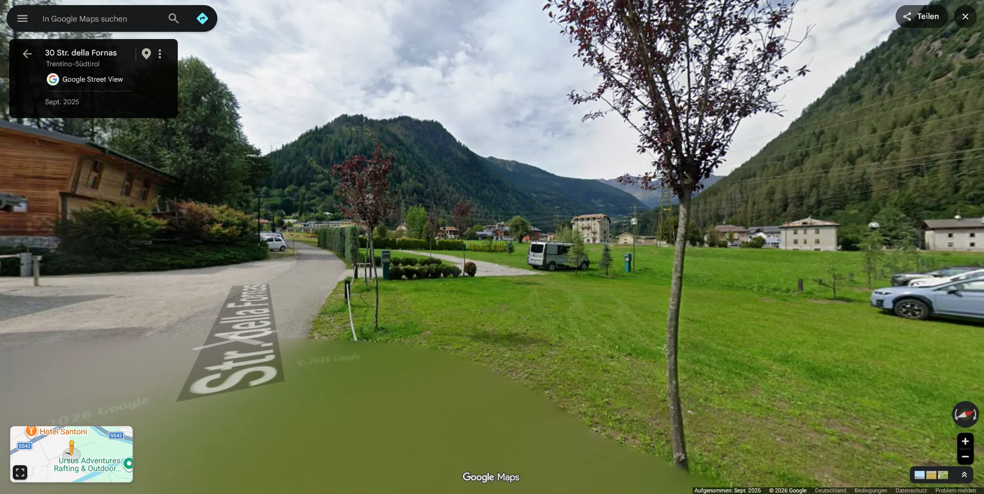
Same lamp, same hedge, same teal column, same mountain profile. Where the black squares were, Street View shows sky, path and grass.
Camera position:
46.3110, 10.7367Flag:
hacktoria{46.3110,10.7367}(Or the equivalent Google Maps URL, depending on what the checker accepts.)
Takeaways
- Check what a redaction actually covers. Black boxes over sky and grass hide nothing; they are a signal pointing elsewhere. Here the count matched the poem’s four landmarks, and the poem carried the solve.
- Multi-constraint beats single-clue. One clue narrows a continent to a country. Four simultaneous constraints in walking distance of each other narrow it to one village.
- Rank your constraints by rarity. “Castle on a rock in a valley floor” filtered harder than everything else combined. Start with the rarest feature, not the first one listed.
- Scope before you search. The same constraint that’s useless globally becomes surgical once the image analysis has narrowed the region. Image → region → query, in that order.
- Terrain profile is an underrated filter. Vegetation, slope steepness and summit shape rule out entire countries faster than any sign or lamp post.
- And yes: globe streetlamps exist outside of England. Ask me how I know.
Sources
- Ossana — Wikipedia — village, Castello di San Michele on its rock spur
- Google Street View — Str. della Fornas, Ossana (imagery Sept. 2025), the camera-position match
- OpenStreetMap — campo sportivo, campground, cycle path geometry
- Challenge: Hacktoria — “Corrupted”