Fire: Finding the Building Behind a Smoke Plume on Street View
Hacktoria GEOINT. A 2021 Street View frame with a black smoke plume over Flemish fields. Two wrong countries on the way, one search operator that mattered, and a press photo that pinned the house number.
Title: Fire
Description: Investigate this fire. What is the address and house number that was lost in the fire?
Flag:
Hacktoria{Streetname_Housenumber}
The answer, up front: the smoke comes from a burning business building on the Meensesteenweg in Izegem, West Flanders, Belgium, on 11 August 2021. The building that burned is number 242. The frame itself was taken about 2 km north-west of it, on the Weststraat. Hacktoria accepted the flag.
Hacktoria{Meensesteenweg_242}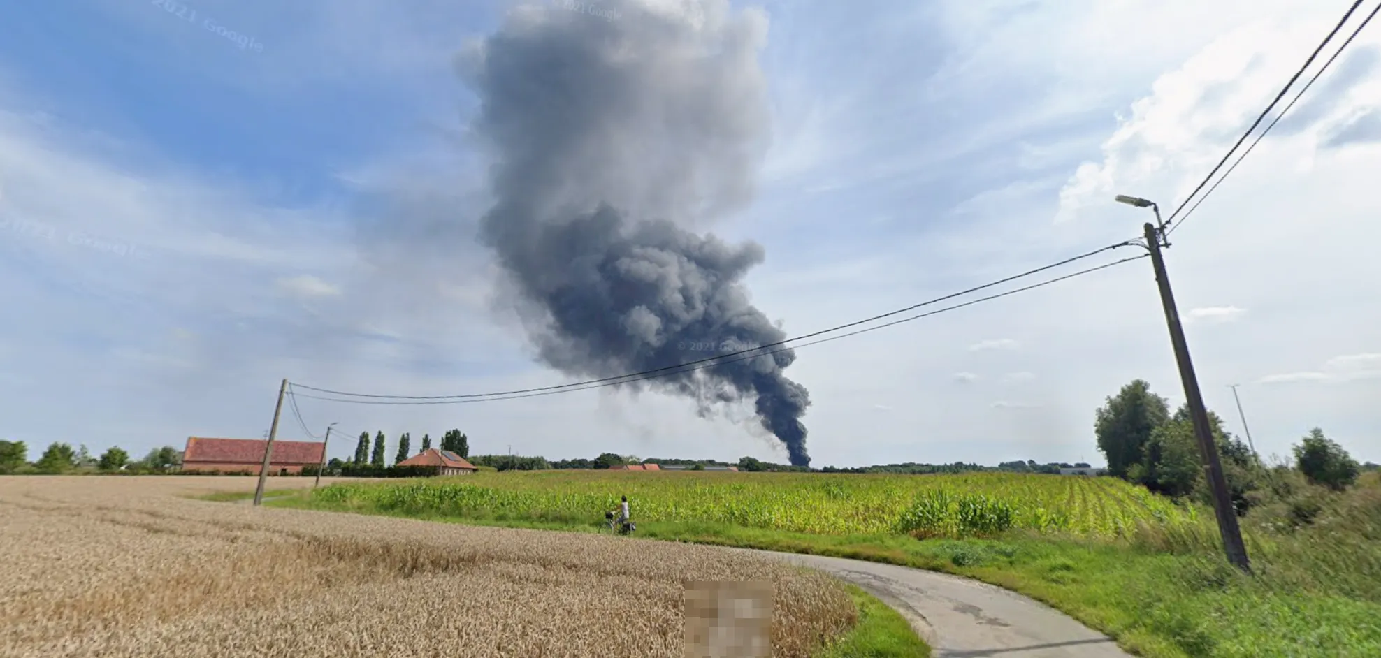
The whole brief. A Street View frame with the ”© 2021 Google” watermark, no street sign, no house number, no readable text. The watermark is the only date.
Step 1: Read the picture
What’s in the frame:
- Four poles carrying overhead low-voltage wires, one with a street lamp on top
- A ripe wheat field next to a maize field at full height: high summer, July or August
- © 2021 Google: the capture year
- A red-brick farmhouse with a red tile roof, poplars, completely flat land
- A black smoke plume. Black smoke means burning rubber, plastic or fuel, not straw or wood. A fire that size, visible over open country, ends up in the local news.
That last point decides the method: find the country, then the fire, then the building. The fire is a news event, so the news will carry the address.
Step 2: Two wrong countries
Wrong turn 1: the Netherlands
Flat, fields, brick: my first guess was the Netherlands. I compared against Plonk It and the poles don’t fit. The Netherlands buries most of its low-voltage grid, and a farm road with overhead lines on concrete poles is rare there.
Wrong turn 2: Sweden, half an hour
A street lamp on the pole that also carries the wires looked like a Swedish pattern I remembered from Plonk It. I spent about thirty minutes there before checking the pole itself. Swedish poles are wood: round, brown, with the lamp arm clamped to the side. The challenge pole is concrete, square and grey. Same idea, different material. Maize and red brick farmhouses don’t fit Sweden either, and that alone should have ended it sooner.
A red-brick house then reminded me of Belgium. Denmark came up for a moment for the same reason, and I checked Belgium first.
Step 3: Belgium, confirmed by the pole
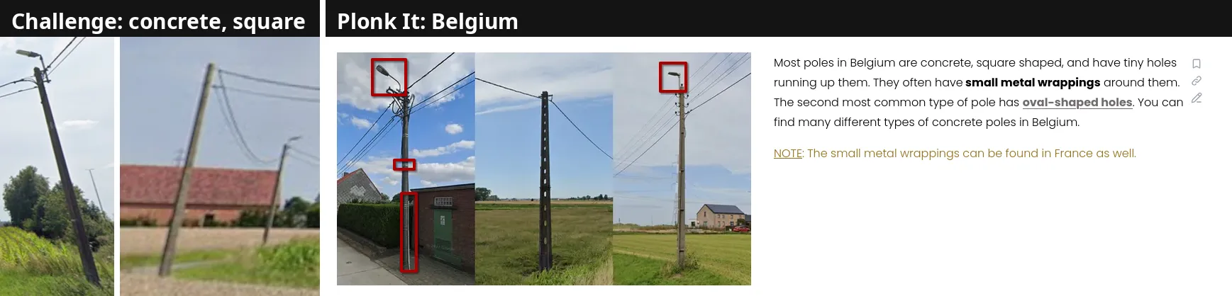
The challenge poles next to Plonk It: Belgium. Square concrete, lamp on the pole top. That’s the Belgian standard pole.
Plonk It’s Belgium page shows it first: most Belgian poles are square concrete, often with small holes and metal wrappings. That matches. I drove north in Street View for a while, compared a few poles and they matched.
The same page narrows the region. Belgium is flat in the north-west and gets hillier towards the south-east, and red brick is most common in the north and west. Flat fields plus red brick means Flanders.
Certainty: high for Belgium, medium for Flanders. Northern France shares the metal wrappings, but not the brick farmhouses and the flat maize country together.
Step 4: Find the fire in the Flemish press
I don’t read Dutch, so I had the search strings translated. The English version found nothing useful:
plume of black smoke visible for miles august 2021The Dutch version got closer, but Google quietly dropped the date. Under the results it says “Es fehlt: augustus 2021” (“missing: augustus 2021”). It was searching for any black smoke plume, any year.
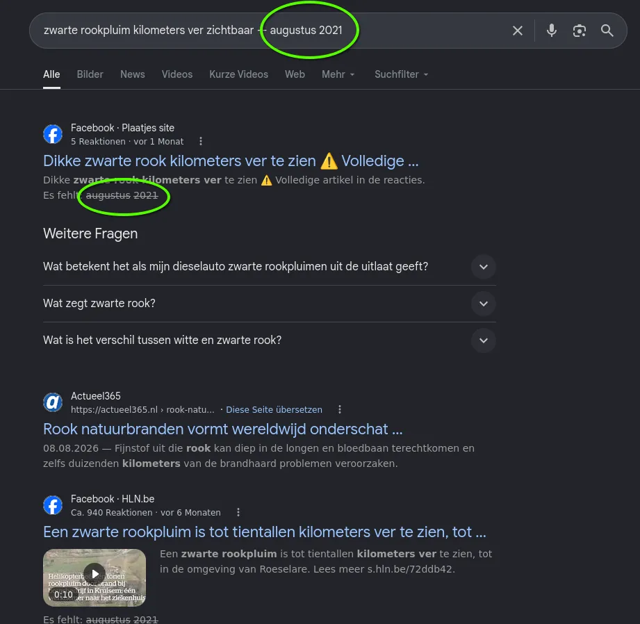
Google struck “augustus 2021” out of the query. Without the date, the results are about any fire.
Putting the year in quotes forces it into the match:
zwarte rookpluim kilometersver zichtbaar — augustus "2021"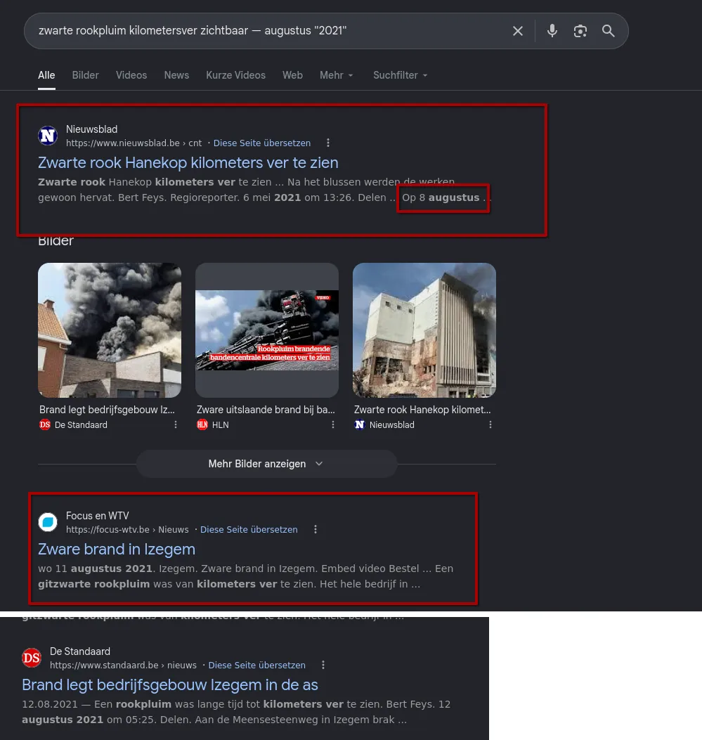
With “2021” forced: the first hit is wrong (Hanekop, May 2021), the second is the fire. Focus-WTV on 11 August 2021, De Standaard the next morning naming the street.
The first hit is a fire from May 2021, so it’s out. The second is Focus-WTV: Zware brand in Izegem, 11 August 2021: een gitzwarte rookpluim, a pitch-black plume visible for kilometres. De Standaard adds the street: Meensesteenweg, Izegem. A tyre centre burned there, which explains the black smoke.
Certainty: medium. Date, season, region and smoke colour all fit, but the articles give no house number, and Flanders has more than one fire per summer. The match has to come from pixels.
Step 5: The building, from the press photo
De Standaard’s photo shows the fire from the street: a white two-storey commercial building with a band of windows, a small sign on the facade, and a red-brick house with a chimney on the left. I walked the Meensesteenweg in Street View on the August 2021 capture, looking for that facade.
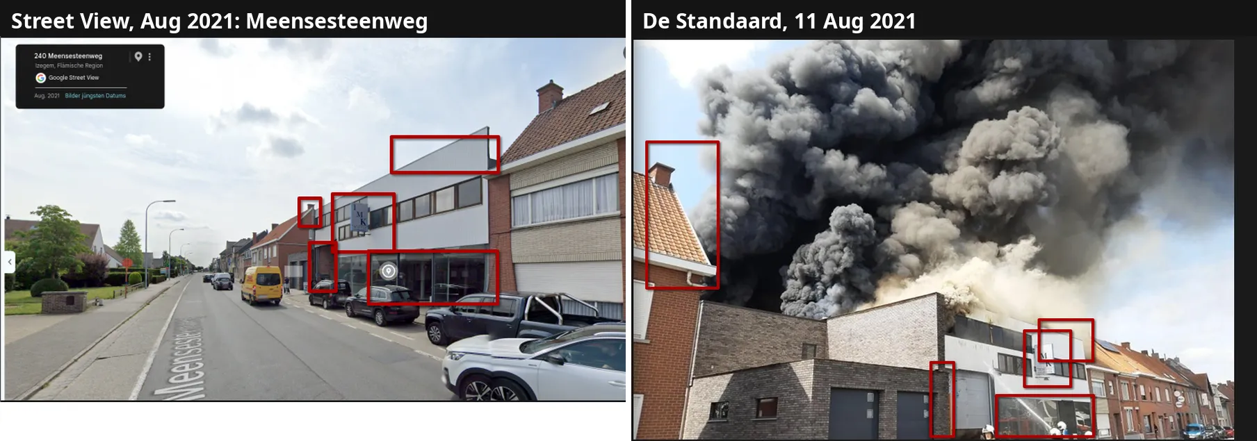
Street View on the Meensesteenweg, August 2021, next to De Standaard’s photo of the fire. The same boxes in both: roof edge, chimney of the neighbouring house, the small “IMK” sign, the window band and the glass shopfront.
The IMK sign settles it. A small blue sign on a white facade, in the same place on both images, together with the neighbouring chimney and the window band. Street View labels the building 242 Meensesteenweg.
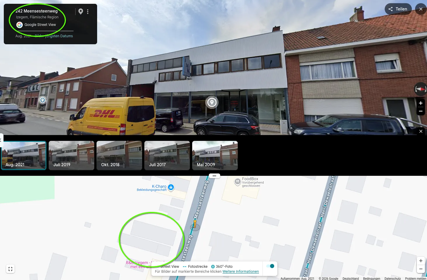
The address panel reads 242 Meensesteenweg. The timeline shows the building standing from 2009 to August 2021, so the August 2021 capture shows it before the fire.
Bonus: where the frame was taken
The question only asks for the burned building, but the challenge frame itself can be placed too. Its foreground is a wheat field on one side of a curving road and a maize field on the other. On satellite imagery ripe wheat shows as pale, maize as dark green. I circled field pairs in the countryside around Izegem that sit north-west of the Meensesteenweg and are on a road that bends like the one in the frame, then crossed them off one by one.
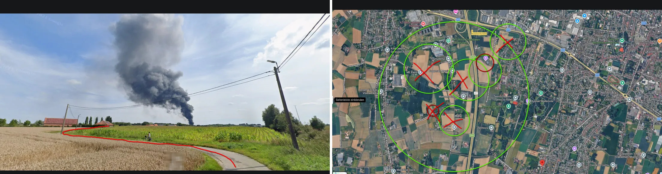
Road curve traced on the challenge image; candidate field pairs on the satellite image, crossed out until one was left.
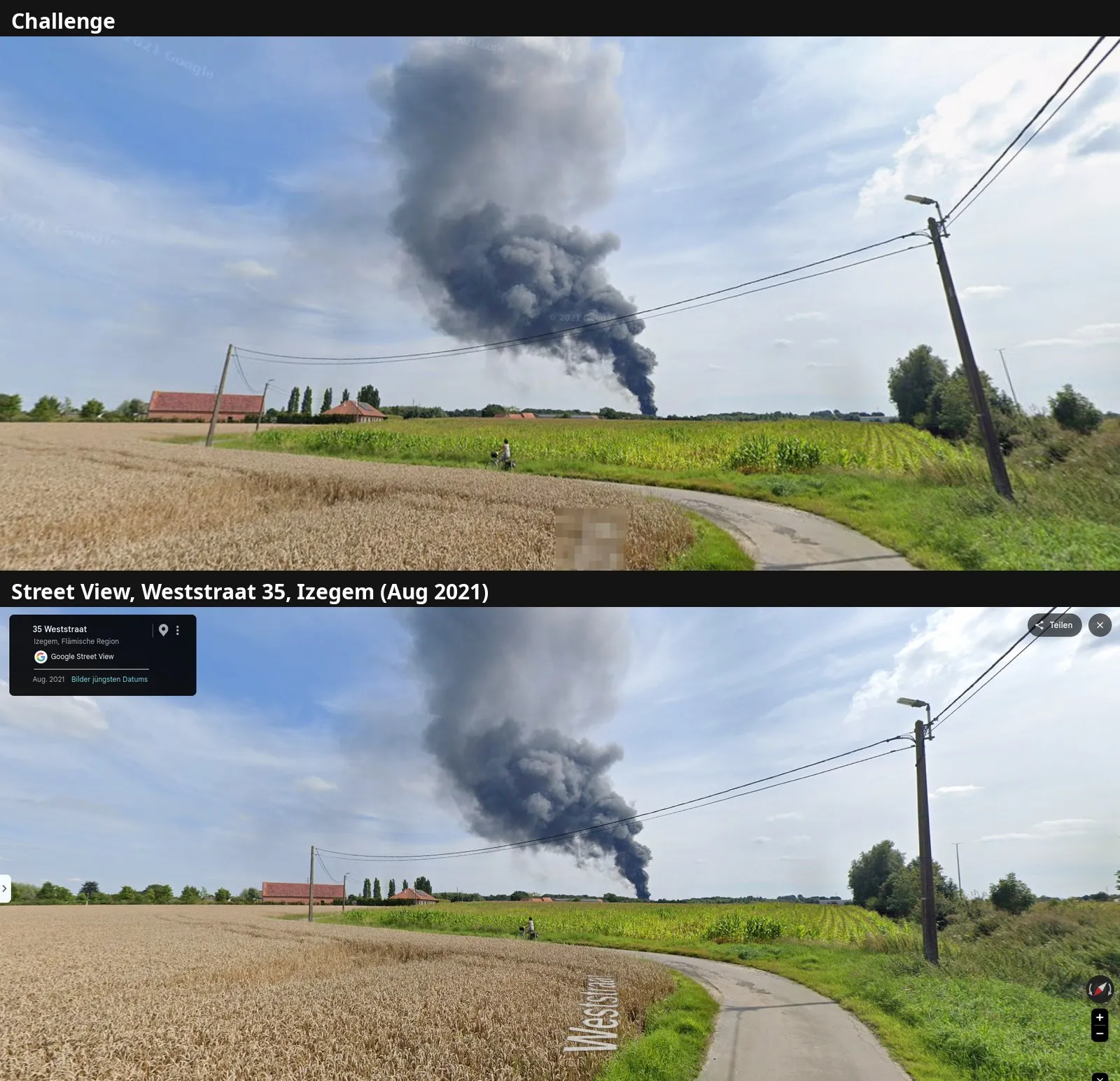
Challenge above, Street View below: Weststraat, Izegem, August 2021. Same field pair, same leaning pole, same cyclist, same plume. The Street View car drove past while the tyre centre was burning.
Flag
Hacktoria{Meensesteenweg_242}Meensesteenweg 242, 8870 Izegem, Belgium, approx. 50.90070, 3.19117 (OpenStreetMap geocode of the address). Fire on 11 August 2021. The frame was taken on the Weststraat, Izegem, roughly 2 km north-north-west.
Takeaways
- One matching feature isn’t a country. A lamp on a wire pole exists in Sweden and in Belgium. Check the pole’s material, then check it against the crops and the houses. Maize plus red brick was never going to be Sweden.
- Check whether Google dropped part of the query. A date inside a query is often dropped silently. The “missing:” line under a result tells you, and quotes (
"2021") force the term back in. - The news gives you the street, the photo gives you the number. Articles rarely print house numbers. Their photos do show facades, and a facade matched against dated Street View is proof, not a guess.
- Use the capture date to your advantage. A Street View capture from the month of the event is the last look at the building before it burned.
Sources
- Hacktoria: challenge “Fire”
- Plonk It: Belgium, poles, red brick, regional terrain
- Plonk It: Netherlands
- Focus-WTV, 11 August 2021: Zware brand in Izegem
- De Standaard, 12 August 2021: Brand legt bedrijfsgebouw Izegem in de as
- VRT NWS, 11 August 2021: Izegemse bandencentrale staat in brand
- Google Maps / Street View: 242 Meensesteenweg, Izegem (captures 2009 to August 2021); 35 Weststraat, Izegem (August 2021)
- OpenStreetMap / Nominatim: Meensesteenweg 242, Izegem