Pulling Focus: What Is This Blurry Building by a Kyrgyz Highway?
Bellingcat Globetrotters. A blurred photo from a moving car, one Cyrillic sign and no building name. The letter Ү pointed to Kyrgyzstan, Google fixed a half-read village name, and a 2015 Street View pass pinned the junction on the A365.
Title: Pulling Focus (Bellingcat Challenge, Globetrotters series)
Description: When Aiganysh was travelling by car, she took this photograph of a building. Despite her best efforts, the building came out a little blurry.
Question: Can you figure out what the building is used for? What is the function of this building?
The answer, up front: it’s the village library of Kazan-Kuygan, a village on the A365 in Naryn Region, Kyrgyzstan. The sign in front of the building names the village. A 2015 Street View pass matches the junction, and the building is labelled on the map. The challenge site accepted the answer.
LibraryThe question asks what the building is for, but nothing in the photo says so: no nameplate you can read, no logo. So this is a geolocation challenge first. Once you know which building it is, the map tells you what it’s used for.
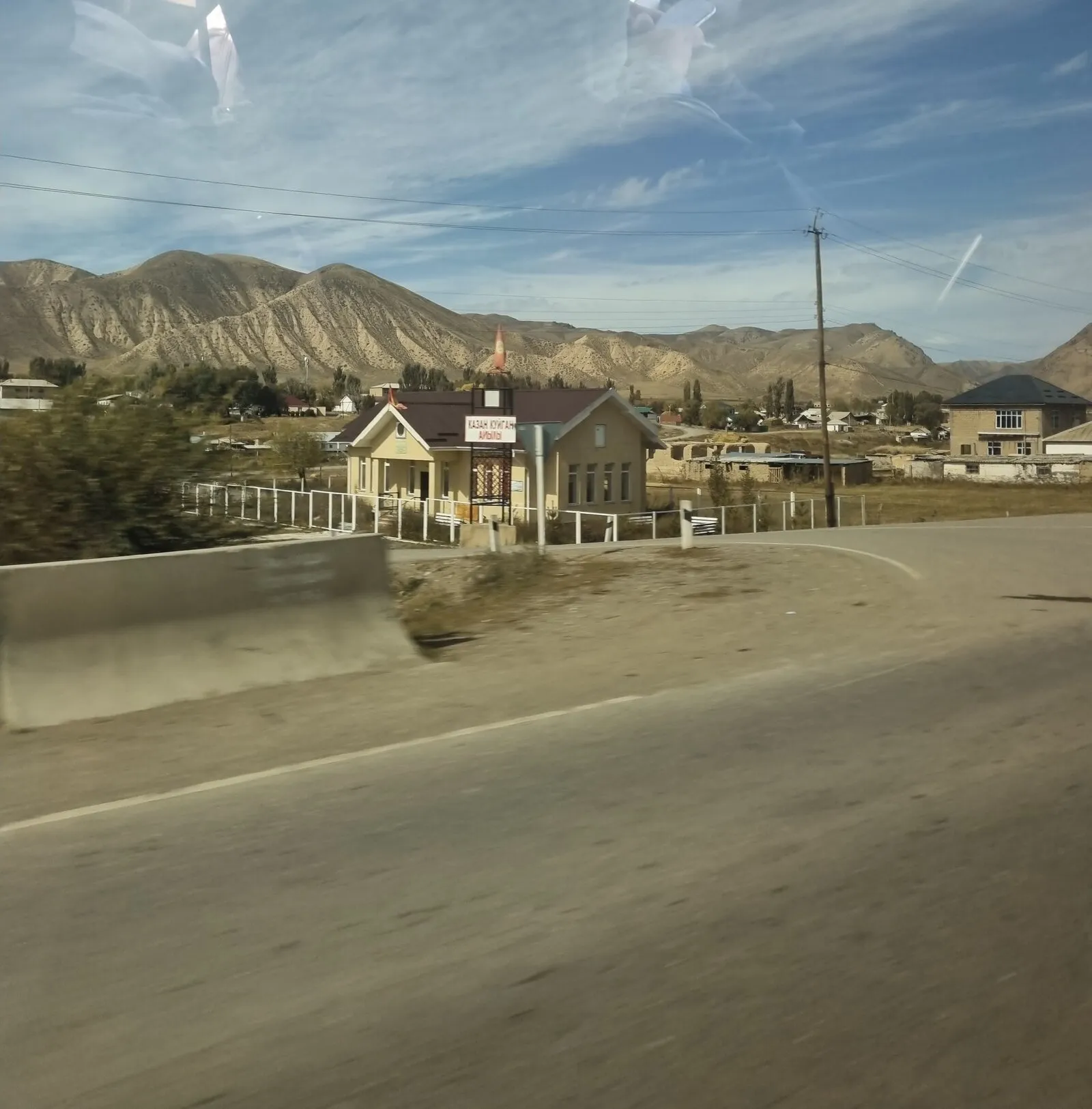
Motion blur, reflections in the window, and a bend in the road with a side road next to the building. The only text is the sign in front of the building.
The file still has partial EXIF: date 2024:09:29 12:14:57, time zone offset +06:00, and phone camera settings (f/1.8, 5.4 mm). There are no GPS tags. The offset is worth keeping in mind. In September 2024, UTC+6 meant Kyrgyzstan, Omsk in Russia, Bangladesh or Bhutan (Kazakhstan had moved entirely to UTC+5 that March). It’s a hint, not a location.
Step 1: What’s in the frame
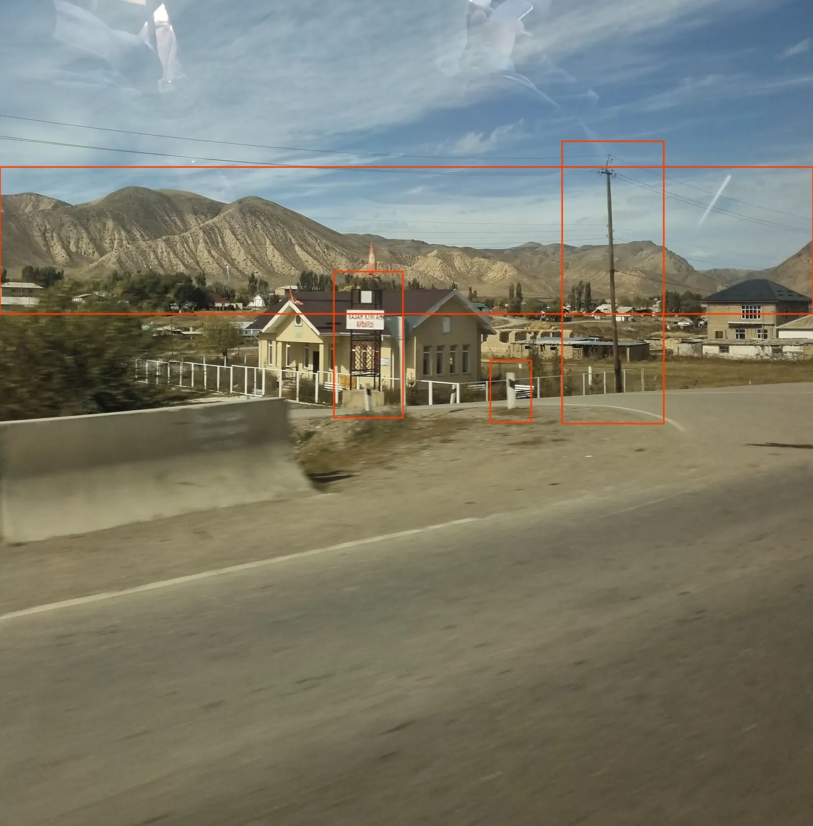
The fixed features to match later: the mountain ridge, the sign frame, the roadside post and the utility pole.
- Mountains: bare, eroded, tan ridges with deep gullies. Dry, high ground, no forest.
- Road furniture: white roadside posts with a black band, a concrete barrier, a wooden utility pole.
- The sign: red Cyrillic letters on white, on a black steel frame in front of the building.
- The flag on the roof: red with a yellow centre.
- The road bends, and a side road branches off beside the building.
The Cyrillic narrows it to the former Soviet space. The landscape narrows it to somewhere dry and mountainous, which rules out most of European Russia.
Step 2: Read the sign
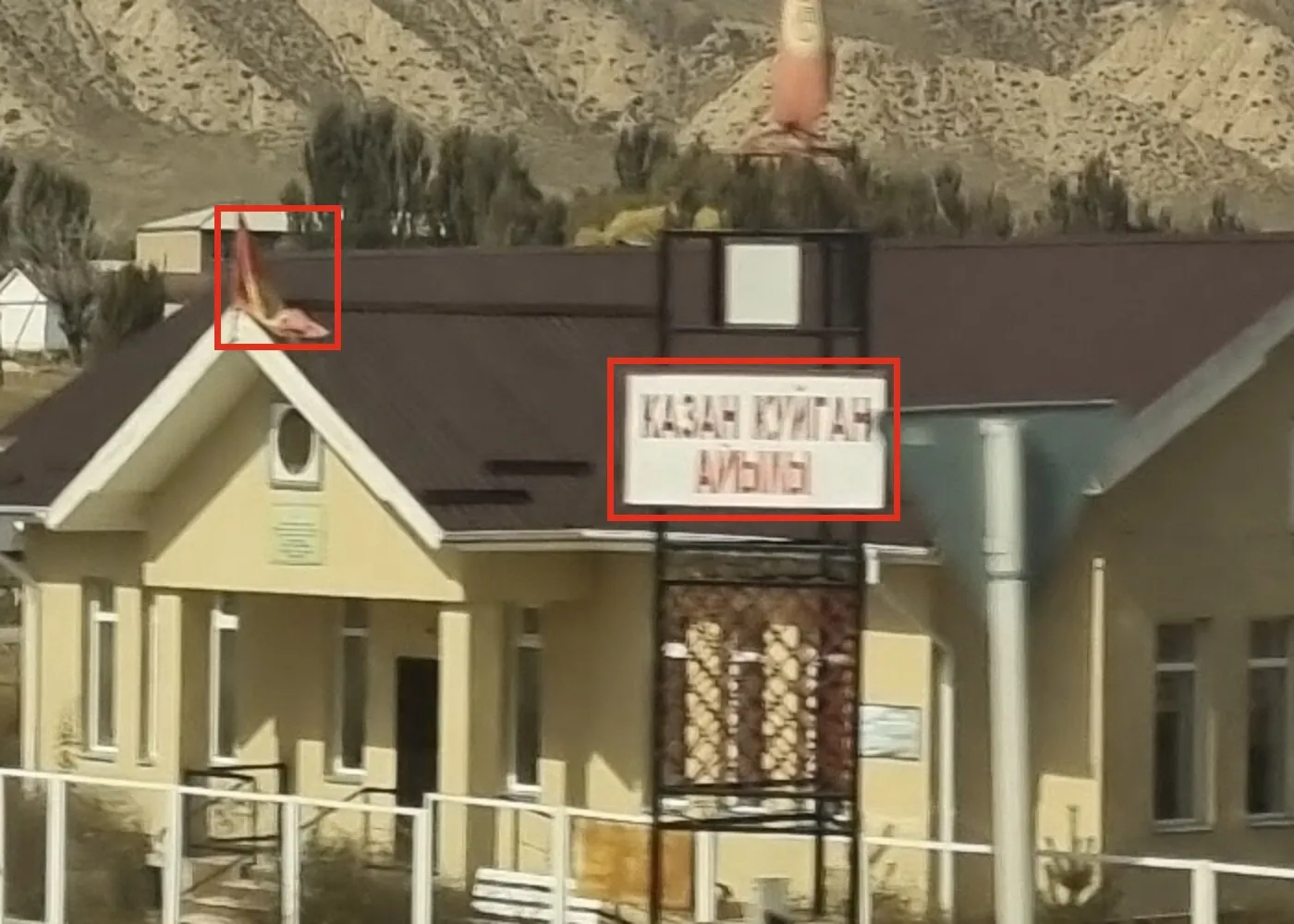
The sign: КАЗАН КҮЙГАН on the first line, a blurred word ending in -Ы on the second. The flag on the roof is red with a yellow centre, the Kyrgyz colours.
The first line reads КАЗАН КҮЙГАН. The second line is blurred badly enough to read as АЙЫЫ.
To search for it, type it in Cyrillic, not a guessed transliteration. Any system keyboard with a Russian or Kyrgyz layout works, or an online Cyrillic keyboard.
The decisive letter is Ү (U with a straight tail). Russian and Ukrainian don’t have it. Kyrgyz, Kazakh, Mongolian, Bashkir and Tatar do. Together with the red and yellow flag and the UTC+6 offset, that points hard at Kyrgyzstan.
False leads: Russia, Ukraine, and “the bear in the pots”
- Russia was the first guess, from the Cyrillic alone. The Plonk It guide for Russia didn’t fit the road furniture and the landscape.
- Ukraine was ruled out by the second line: it has the letter Ы, which Ukrainian doesn’t use.
- Google Translate turned
КАЗАН КУЙГАН АЙЫЫinto “the bear in the pots”. It makes no sense for a building with a flag on the roof and a rocket-shaped monument behind it. It happens becauseАЙЫЫisn’t a word: the blur swallowed a Л. Казан is “cauldron”, and айы on its own gets read as “bear”. The translation was nonsense because the input was wrong, and that was the useful part.
Step 3: Let Google fix the misreading
Search the misread text as it is:
КАЗАН КУЙГАН АЙЫЫ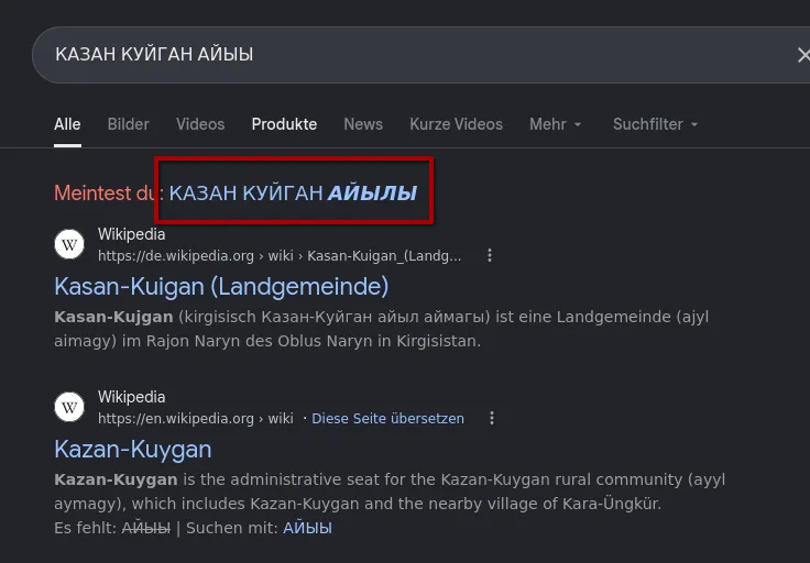
Google suggests the missing Л: АЙЫЛЫ. Kyrgyz айылы means “village of”. The sign is a village name sign.
Google’s “Did you mean” puts the missing letter back: КАЗАН КУЙГАН АЙЫЛЫ, “the village of Kazan-Kuygan”. Wikipedia confirms that the place exists: Kazan-Kuygan is a village in Naryn District, Naryn Region, Kyrgyzstan, and the administrative seat of its rural community.
How sure? A sign like this stands at the entrance to the village it names, so the photo was taken in or right next to Kazan-Kuygan. There is only one village of that name in Naryn District, and the Ү, the flag and the time zone all agree.
Step 4: Find the bend
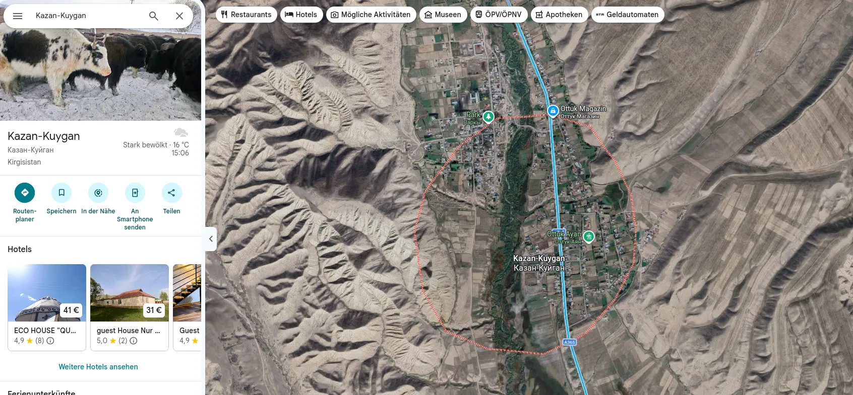
Kazan-Kuygan on Google Maps. The A365 runs along the village, which keeps the search small.
The village is a strip along one road, the A365, the main road from Naryn north to Balykchy and Lake Issyk-Kul. The photo was taken from a car, so the photographer was almost certainly on the A365.
Two constraints from Step 1 decide which stretch:
- The road bends, with a side road leaving it next to the building.
- The high ridge is on the left of the frame, beyond the building.
The approach: drop into Street View on the A365 and check every bend through the village until the ridge line matches.
Step 5: The Street View match, and why the building isn’t there
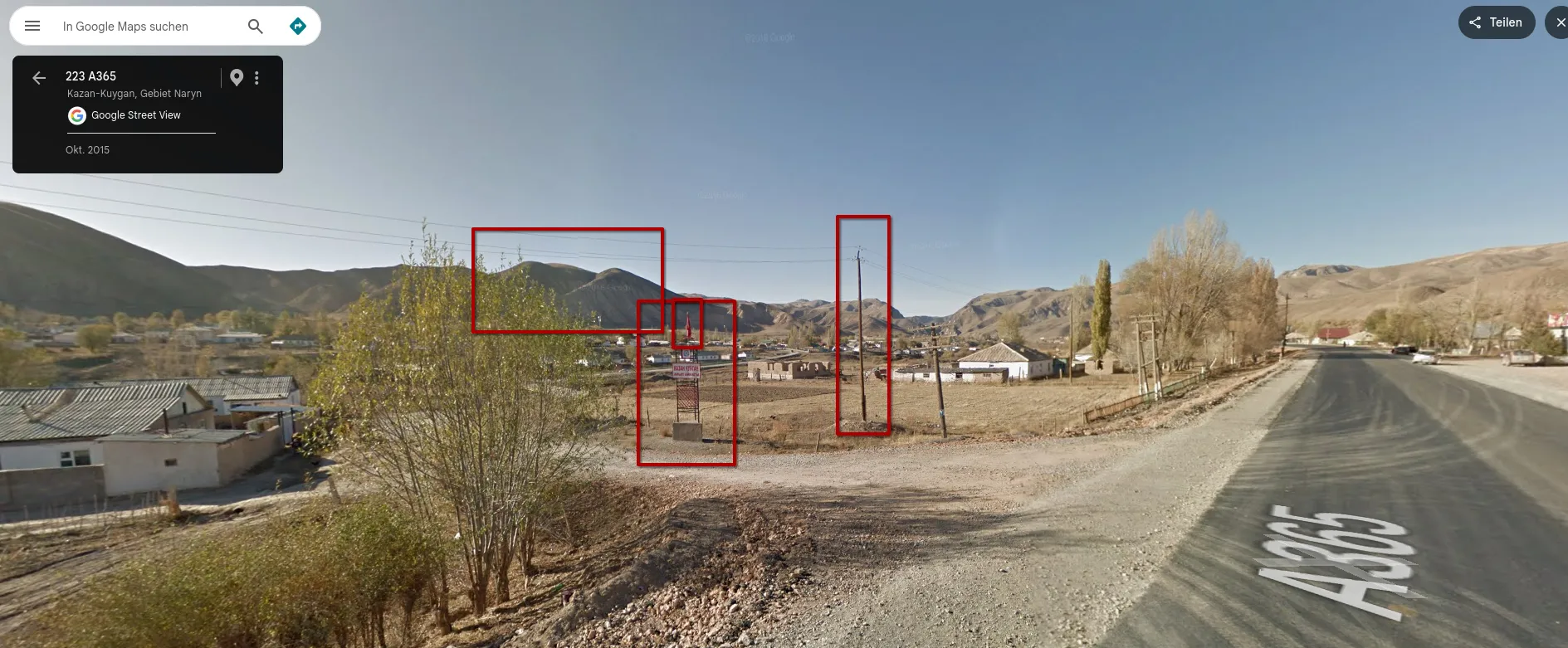
Street View, October 2015, at “223 A365, Kazan-Kuygan”. The ridge, the sign frame on its concrete base and the utility pole are in the same arrangement as in the challenge photo. The building isn’t there yet.
Street View at 223 A365 (October 2015) shows the match:
- the same ridge with the same double summit,
- the same black sign frame on a concrete base, next to the side road,
- the same wooden utility pole to the right of it.
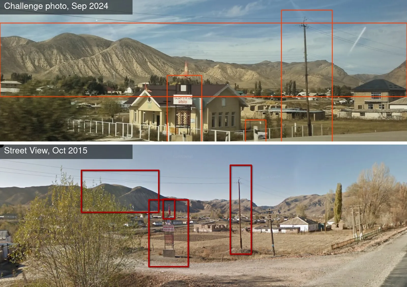
Top: the challenge photo, September 2024. Bottom: Street View, October 2015. The ridge, sign frame and pole are in the same order from left to right. The ruined mud-brick walls behind the plot are in both frames too. Only the building is new.
The building is missing. In 2015 the plot behind the sign is empty ground. It’s a newer building than the Street View coverage, so a pure Street View match can only ever confirm the setting, not the building itself. The fixed features that stood before and after the building carry the match.
The moment it’s settled: three independent fixed features (ridge line, sign frame, utility pole) line up in the same arrangement in two photos taken nine years apart.
Step 6: What the building is for
Switch to satellite view at the junction. The newer imagery shows the building on the corner between the A365 and the side road, around 41.62951, 75.84547.
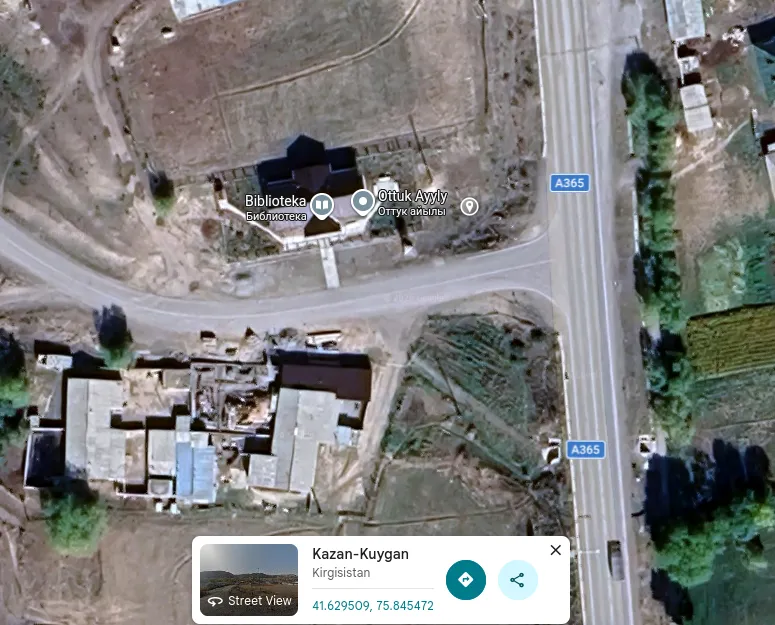
On the satellite image, the building at the junction carries the Google Maps label Biblioteka (Библиотека, library).
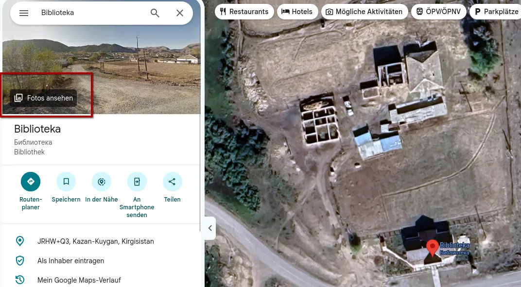
The place card: Biblioteka, JRHW+Q3, Kazan-Kuygan. “See photos” leads to the user photos.
Among the place’s photos is a user upload (December 2025) from exactly the same spot:
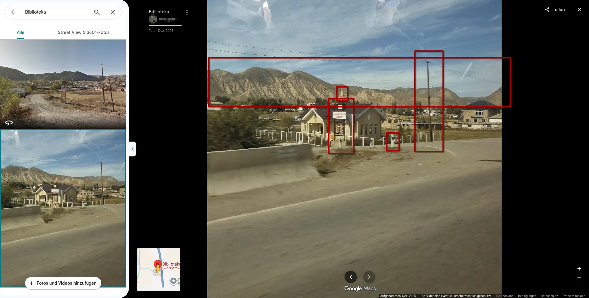
The user photo on the “Biblioteka” place. It’s the challenge photo itself, with the same window reflections, uploaded to the place.
A caveat that matters: look closely and this isn’t just the same place, it’s the same photo, down to the reflections in the car window. Someone uploaded the challenge image to the place. So it proves that Google’s “Biblioteka” pin sits on this building. It says nothing independent about what the building is.
Verification: what’s independent and what isn’t
Two sources that look like confirmation turn out to lead back to the challenge itself:
- The Google Maps user photo is the challenge photo (see above).
- OpenStreetMap also has the building as
amenity=library(way 1339778704). The changeset from 3 December 2024 says, in its comment: “Adding a library based on an open source challenge.” That’s a solver mapping their answer, not a local source.
What is independent:
- The Street View match (Step 5) is independent of any label: it places the photo at this junction.
- The Kyrgyz Wikipedia article on Казан-Куйган, based on the 2011 Kyrgyzstan national encyclopedia, lists a китепкана (library) among the village’s facilities. That shows a library exists in the village, though not which building it is.
- The challenge accepted “Library”.
How sure? The location is certain. The function rests on the Google Maps label, whose origin I can’t check, backed by the encyclopedia’s library and the accepted answer. For a challenge that’s enough; for a real report I’d want a sign on the facade or a local source that names the building.
Answer
LibraryVillage library of Kazan-Kuygan (Казан-Куйган), A365, Naryn Region, Kyrgyzstan, 41.62954, 75.84514.
Takeaways
- Individual letters narrow down the country. Ү, Ө and Ң rule out Russian and Ukrainian, and Ы rules out Ukrainian. Check the alphabet before you check the landscape.
- Search what you can read, even if it’s wrong. A blurred sign typed in exactly as seen, in the original script, got a “Did you mean” that fixed the missing letter. Transliterating first would have lost that.
- Nonsense translations are data. “The bear in the pots” didn’t fit the scene, and that was the signal that the input was misread.
- Newer than Street View is normal. When the building is missing from the old pass, match on what was there before and after it: ridges, poles, sign frames.
- Check where a confirmation comes from. The OSM tag and the Maps photo both looked like second sources and both came from the challenge. Changeset comments and upload dates tell you which is which.
Sources
- Bellingcat Challenge 3: Pulling Focus
- Plonk It: Russia
- Wikipedia: Kazan-Kuygan
- Kyrgyz Wikipedia: Казан-Куйган (after the Kyrgyzstan national encyclopedia, vol. 3, 2011)
- Google Maps / Street View: 223 A365, Kazan-Kuygan (October 2015); place “Biblioteka”, JRHW+Q3 Kazan-Kuygan
- OpenStreetMap: way 1339778704 and changeset 159870797